Free HTML Blog 4u

Wednesday 12 March 2014

About the owner of this blog.. ^_^


Praise to the God for giving me ability in doing this assignment. Finally I had finished this task in the time given. Okay, here I will introduce myself. My name is Qurratu Ainie binti Abdul Halim. I had delivered to this beautiful world by my beloved mom in my town, Kuala Terengganu on 11 November 1992. I am studying at University Malaysia Kelantan (UMK), Pengkalan Chepa, Kota Bharu, Kelantan. My identity number at UMK is A11A364. I like to spend my time on social media such as Facebook, Twitter and so on. This is because I can get the latest news as soon as possible there. As we know, as a student it is also important to know the current issues in and out of the country. For example, now the MAS flight with registration number of MH370 is still missing, so we can follow the fast update about the news and continuously pray for them. Then, about my ambition, I want to be a successful entrepreneur in the future. I have planned to open a beautiful and attractive baby stuff soon. As I am studying in Faculty of Entrepreneurship and Business in Retailing, with the various of good knowledge, insyaAllah I will strive to achieve the ambition.

Last but not least, about this awesome assignment(15 Attractive Places In The World) , I think it is very different and creative assignment I ever had. From this, I can learn many things, in tourism world especially. Not only in this country, but all over the world. A special thanks for my beautiful and cheerful lecturer, Miss Raja Norliana binti Raja Omar, for this awesome assignment! ^_^

Mendenhall Ice Caves of Juneau in Alaska, United States - "Glacier Behind the Town"


The Ice Cave

In few places can you experience every stage of the water cycle at once. But there's magic in the Mendenhall Ice Caves, where water runs over rocks under blue ceilings inside a partially hollow glacier.


The Mendenhall Glacier is a 12-mile-long glacier in the Mendenhall Valley, located only 12 miles from downtown Juneau in Southeast Alaska. Federally protected as part of the Mendenhall Galcier Recreation Area, a unit of the Tongass National Forest, the glacier originally had two names, Sitaantaagu ("Glacier Behind the Town") and Aak'wtaaksit ("Glacier Behind the Little Lake").

One of the tourist there

The Ice Caves are inside the glacier, accessible only to those willing to kayak to, and then ice climb over the glacier. However, the glacier is retreating increasingly fast as global warming heats the oceans and temperatures rise.
Monitored since 1942 by the Juneau Icefield Rsearch Program, the Mendenhall Glacier has receded almost 2 miles since 1958, while previously it had receded only 0.5 miles since 1500. The caves are in part a function of this increased glacial melting.


Images of the caves circulate the internet with such captions as "otherworldly" and "surreal," but "melting" and "fleeting" could be used as well, as this glacier creates incredible new landscapes while we watch it melt away.

The Wildest Swing in Your Life in Ecuador


The Wildest Swing

Casa Del Arbol, BaƱos, Ecuador. If you thought that riding a swing is for kids, think again. Here is the wildest swing in the world: the swings hanging from Casa Del Arbol above the abyss attracts many brave adventurers.

The treehouse actually is a seismic monitoring station. From here an incredible site of the Cordillera Real and an active volcano Tungurahua opens. The hikers reach this spot on their way to Bellavista viewpoint.

The swing is simply made of a metal beam attached to a rope. No safety belts will keep you from falling down the abyss. However, the bravest hikers take their chances and enjoy the exciting experience. Definitely worth trying at least once in your lifetime!


The Wildest Swing in Your Life in Ecuador


Tuesday 11 March 2014

The Isle of Skye, Scotland - The Magical Isle


The welcoming board


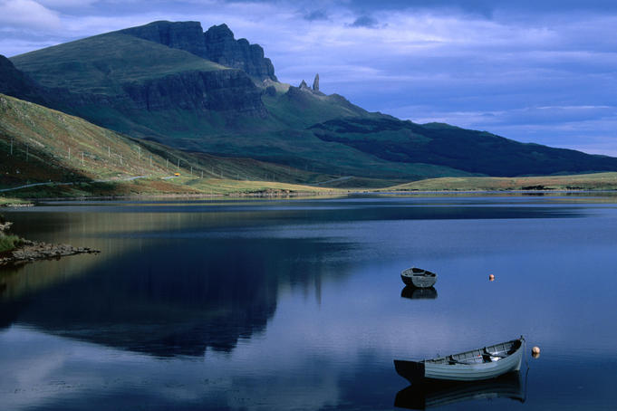
The Isle of Skye is a gem of an island, lying off the west coast of Scotland, with beautiful mountain scenery, interesting geology, stunning sea lochs and plenty of wildlife.

The scenery at The Isle of Skye

It's also just become the first place in the world to be 'virtually twinned' after being twinned with the fictional isles of Skylands as part of the promotion of the new Skylanders video game.

The Hebrides beds and

Skye is the largest of the Inner Hebrides lying of the west coast of Scotland and its landscape is distinctly Highland with its lochs, heather-clad moors and towering peaks.

Despite its small size, Skye boasts an impressive 20 Munros, making the island a favourite with hillwalkers keen to tackle the heights of its Cuillin mountain range. The Black Cuillin is famous for its dramatic jagged ridge and the Inaccessible Pinnacle, a 150 ft rock making Sgurr Dearg the only Munro in Scotland with a summit that can only be reached by rock climbing.

Under the shadow of the towering Black Cuillin lies Loch Coruisk. With its reflective waters and mountain scenery, the loch is considered to be one of the most beautiful sights in Scotland.

The Old Man of Storm rock formation on the Isle of Skye

Aside from the Munros, Skye features many other geological marvels such as the breathtaking landslip formation, the Quiraing, the astounding sea cliff of Kilt Rock on the rocky coastline of Trotternish, and strange rock pinnacles like the Old Man of Storr. The Faerie Pools of Glenbrittle are fast becoming a popular place for a swim thanks to its beautiful clear waters and spectacular surrounding scenery.

The character of Skylander, Wash Buckler to promote the island's twinning

It was this beautiful scenery that led to the recent unique twinning partnership between the Isle of Skye and the virtual world of Skylands. In the world's first every 'virtual twinning', Skye has provided some of the backdrop for the exciting new Skylander SWAP Force game, with key character Wash Buckler already having visited the island. The game brings toys to life by combining the physical characters playing in a virtual word with the ability to swap the top and bottom halves of the interactive figures.

The red deer

Skye’s scenic landscape also provides a home for an abundant array of wildlife. Red deer, Scottish wildcats, pine martens and mountain hares roam the hillsides while around the coast you are sure to spot seabirds, seals and, if you are lucky, otters. In summer, why not take a boat trip, where you may catch a glimpse of dolphins, sea eagles and golden eagles? There are several companies providing boats trips around Skye, including Misty Isle Boat Trips, Elgol Boat Trips and Bella Jane Boat Trips.

Saturday 8 March 2014

Lavender Fields of Provence, France - The Soul of Provence


The lavender's field
The colour, the texture, and the scent of a lavender field encapsulate for many the essence of Provence. You can enjoy the lavender fields by car, by bike or on foot. The map indicates where around the Luberon you will find concentrations of lavender fields: on the high plateaux around Sault, at the foot of the Mont Ventoux, and around Apt and Gordes.

The lavender in the Luberon blooms from around the last week of June to the beginning of August when it is harvested. It is usually at its peak in early July, but this depends on the rainfall in the year.

The sunflower together in July- August

If you want to see sunflowers and lavender together, sunflowers are in full colour in July-August. You may also find lavender fields that contain a stone borie, which makes a more interesting photo than just the lavender.

The Simiane la Rotonde view from the lavender field

On the way to Sault you will pass the village of Simiane la Rotonde, which is a picture-perfect, perched village with fields of lavender at its base – an ideal spot to dabble in photographing the swathes of blue and purple.

In front of Senanque Abbey
Perhaps the most famous lavender shot in Provence is of the field in front of Senanque Abbey near Gordes. It is almost impossible not to get a memorable photo here. The best time to come is early because the light is in the right position in the morning, and it will be less crowded – a lot of people want to get this shot.

Apart from gazing at lavender fields, you can also visit lavender farms and distilleries, attend lavender festivals at Sault and Valreas, and buy lavender products like oil, essences, perfumes, soap, etc. In Coustellet there is even a Lavender Museum exploring the history of the cultivation of lavender in Provence also.

Naica Mine, Mexico - The Cave of Crystal Giant


The Crystal Cave of Giants was accidentally discovered in 2000 by miners working in the silver and lead mine at Naica, Mexico. It lies almost 300 meters (900 feet) below the surface of the Earth and it contains the largest crystals known in the world, by far. The largest crystals are over 11 meters long (36 feet) and weigh 55 tons.

The Crystal Cave

The crystals themselves are made of selenite which is crystallized gypsum, the same material used in drywall construction. Except these crystals formed over a span of about half a million years in a hot water solution, saturated with minerals. The the temperature inside the cave remained very consistently hot for the entire time the crystals were growing.

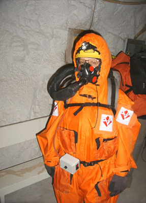
It is still incredibly hot in the cave due its proximity to a magma chamber, deep underground. The air temperature is 50C with a relative humidity of over 90%, making the air feel like an unbearable 105C (228F) Entering the cave without special protective suits can be fatal in 15 minutes. I will be entering the cave wearing a special cooling suit with chilling packs inside and a specialized backpack respirator which will allow me to breath chilled air. Even with all this equipment, I will still only be able to stay in the cave for no more than 45 minutes at a time.

In extreme heat, the body begins to lose higher brain functions which made the expedition much more difficult with the risk of falling into deep pits, or being impaled on a sharp crystal. All the camera gear needs to be slowly brought up to temperature beforehand by pre-heating it and most cameras with moving parts and tape mechanisms simply will not work at all. It is as dangerous as it is beautiful.

The suit provided

The suit provided is based on custom designed, cooling suits only delay the inevitable. As soon as you enter the cave, you begin to overheat and heat stroke and death are inevitable if you remain inside too long. The suits will extend your stay in the cave but it is up to the individual to recognize when you've been exposed too long. 30-50 minutes is the maximum, depending on the individual.

Each suit consists of several layers of protection. First is an insulated vest which protects you from frostbite which you could get from having ice in direct contact with the skin. Then the ice vest which is a series of gel filled pouches, sewn into a mesh vest and kept frozen. This cools you body's core temperature. Overtop of all that is a set of rugged overalls. These keep the radiant heat from the cave away from the ice plus they protect you from the sharp crystals.


 Last but not least is the respirator pack. This custom built backpack is made of insulating foam and contains frozen metal ice bottles. A fan blows air over the bottles and it is pumped up a hose to a face mask which is similar to the type worn by fighter pilots. This system allows you to breathe chilled air as long as the ice remains frozen in the pack.

Wearing the suits, you feel like an astronaut that is about to go on a space walk. In reality, it is not all that different, considering the harsh environment.

How it formed :


Naica lies on an ancient fault and there is an underground magma chamber below the cave. The magma heated the ground water and it became saturated with minerals, including large quantities of gypsum. The hollow space of the cave was filled with this mineral rich hot water and remained filled for about 500,000 years. During this time, the temperature of the water remained very stable at over 50 degrees C. This allowed microscopic crystals to form and grow. Due to the perfect conditions inside, they were able to keep growing until the silver miners pumped away the ground water in order to explore deeper. They accidentally discovered the cave when they broke through back in 2000. Since the cave is no longer submerged, the crystals have stopped growing and cooler air from the mine is lowering the temperature slightly more each year.
 
When the Naica mine is no longer profitable, it is likely that they will just shut off the water pumps and the crystal cave would then disappear forever.

Friday 7 March 2014

Salar de Uyuni, Bolivia - The Largest Salt Flats In The World


The salt desert ( a very amazing reflector place)

Salt Desert of Uyuni is the world's largest salt flat, located in Bolivia. Photographers flock here to capture the unique landscape. It is often visited as part of a 3 or 4 day tour of South West Bolivia, described below.

The Salt

Salt Desert of Uyuni comprises over 10,000km² in the Potosi region. The salt is over 10 meters thick in the centre. In the dry season, the salt plains are a completely flat expanse of dry salt, but in the wet season, it is covered with a thin sheet of water that is still drivable.
The standard tour heads south toward the southwest corner of Bolivia, by many fluorescent-coloured lakes that are created from a collection of different minerals from runoff from the surrounding mountains.

The  type of vehicle that used there

The tour there is usually conducted in 4x4 vehicles (usually Toyota Landcruisers) with 6 or 7 people, with the driver often times cooking. Most 3- and 4- day tours have the same itinerary for the first 2 1/2 days, a day on the salt plains, then heading south to the southwest corner of Bolivia, and then splitting off from there. The specific sites that are seen can be dependent on the tour, but group input can define which sites are visited and how much time will be spent at each.
Accommodation is usually provided in basic refuges and the weather can be very cold, but it is well worth it for the amazing scenery. Avoid tours that offer a night in one of the salt hotels - they are illegal as, not being part of the water grid, they pollute the environment.

Some amazing pictures taken there :

Add caption


For the tourists that want to go there, here are several things that necessary to bring along as it is quiet important :

Flashlight (torch) - the lights go out when the generator runs dry.
Coins and small bills - The bathrooms aren't free.
Sunglasses - The salt flats are blinding.
Camera, extra battery and loads of memory cards - There are no better pictures than here.
Extra water - The tour usually provides an inadequate supply. An extra 2L bottle per day.
Sunblock and hat - At 3.5km above sea level there is significantly less atmosphere to absorb the sun's ultraviolet radiation.
Sleeping bag - You can rent one with the tour. Down is best, and check to see that the zipper works.
Warm clothes - Layered is best.
Hot water bottle - The nights are freezing and you will be so happy to have it.
Flip-flops - The restroom facilities are shared.
Towel - None are available during the tour.
Extra snacks, especially fruit and protein - The food is adequate in quantity but tends to be heavy on starches

So, for those that interested to go there, grab the chance to have a very amazing and gorgeous photos to share with everyone!